FEATURED
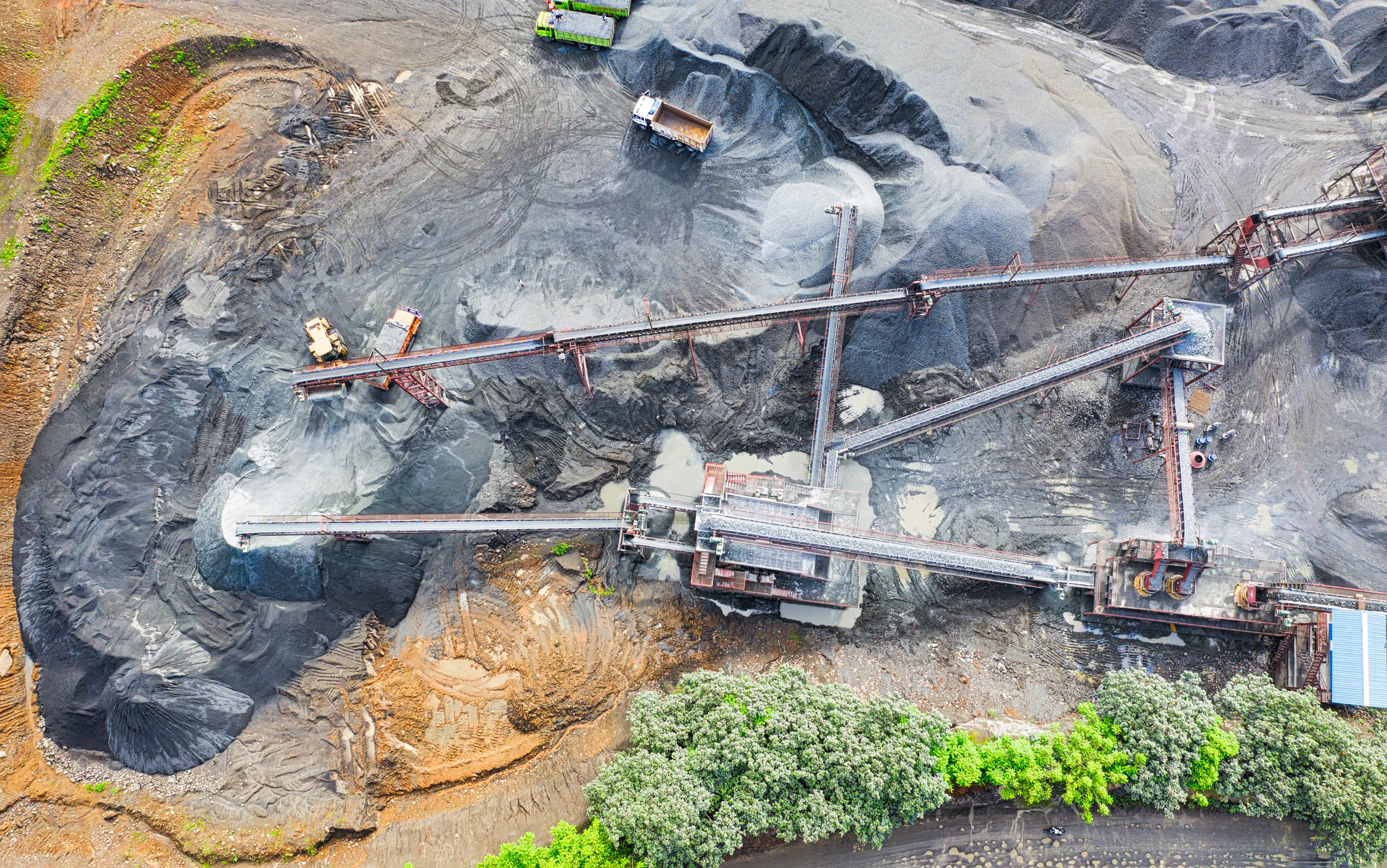
Antiquated facilities, equipment, and processes, together with the continual plague of electricity shortages, will hinder any dramatic production increases of magnesite at North Korea's Taehung Youth Hero Mine.
Recent satellite imagery from November 2019 shows the presence of four specialized railcars that have been associated with the movement of radioactive material in the past. The last observed movement of these railcars by Beyond Parallel was in April 2019. It is unclear whether the railcars are being used for the outbound shipment of irradiated liquid or solid waste, disassembled but contaminated equipment or the movement of fissile material to facilities outside the Yongbyon area. A less likely alternative is the inbound shipment of radioactive material from a facility outside the Yongbyon area.
Collected 14 months after the image provided in Part 5 (November 21, 1968) this March 17, 1970 KH-4B image of the Yongbyon Nuclear Research Center shows continued expansion within the village of Sang-dong, minor improvements in the operations, administration/laboratory and support areas, slowly continuing construction of the bridge across the Kuryong-gang and minor infrastructure improvements in the Pungang-ni area. Taken as a whole, these developments continue to indicate an ongoing first-phase construction project for the facility and very early infrastructure development efforts within a longer-term plan for future expansion.
Analysis of satellite imagery of the Punggye-ri Nuclear Test Facility acquired during 2019 and more specifically on September 23rd and October 9th, 2019 shows the facility in caretaker status, likely being maintained by security personnel. While there is no evidence of current efforts to restore any of the nuclear test portals, several observations lead us to believe the facility has not been permanently disabled and that the detonations in May 2018 are not necessarily irreversible.
The October 2, 2019 Pukguksong-3 submarine-launched ballistic missile (SLBM) test launch has raised concerns over the forthcoming launch of North Korea’s first true ballistic missile submarine (SSB) as described in the Beyond Parallel Snapshot, which was published the same day.
Collected eleven months after the image provided in Part 4 (December 10, 1967) this November 21, 1968 KH-4B image of the Yongbyon Nuclear Research Center does not show any significant developments in the operations (with the IRT-2000 research reactor), support or administrative/laboratory areas. It does, however, show continuing development within the village of Sang-dong and the early stages of construction for a new road bridge across the Kuryong-gang in the Pungang-ni area that will connect the support area to the opposite side of the river. Taken as a whole, these developments represent both continuation of a first-phase construction project for the facility and the earliest infrastructure development stages within a longer-term plan for future expansion.
New CSIS Beyond Parallel imagery shows the undeclared Kumchon-ni missile operating base. This is the first comprehensive public description of the base. During wartime, it is reportedly tasked with striking southern Japan and, to a lesser degree, throughout South Korea.
New Beyond Parallel imagery (August 26, 2019) of Sinpo South Shipyard suggests circumstantial evidence of the construction of a new ballistic missile submarine and preliminary evidence indicates possible preparations for a test.
The Pakchon Uranium Concentrate Pilot Plant is one of only two declared and known uranium concentrate plants in North Korea (Pyongsan Uranium Concentrate Plant at Pyongsan is the other). This facility was used for Yellowcake production at least through the mid-1990s, and therefore would require inspection under any new U.S.-DPRK denuclearization declaration and agreement as it has not been subject to international inspection for over 25 years since IAEA visits to the site as part of the Full Scope Safeguards Agreement process in 1992.
Ryongyang Mine is the largest magnesite mine in North Korea and one of the largest in the world. However, satellite and ground imagery show the infrastructure and technology in use at the mines is dated and obsolete when compared to world standards.
Satellite imagery shows that the new Namyang-Tumen road bridge connecting North Hamgyong province in North Korea with China is nearing completion and could be open to traffic as early as the end of 2019.
Acquired almost two years after the image provided in Yongbyon Declassified Part III (February 11, 1966), this December 10, 1967 image of the Yongbyon Nuclear Research Center is one of the first acquired by the improved reconnaissance KH-4B. Among other improvements, the resolution of the newer KH-4B was 1.8 meters versus 2.7 meters of the earlier KH-4A allowing for considerably better image quality.
As the first sitting president in U.S. history to step into North Korea, Donald Trump’s action could be seen as a significant representation of the U.S. intention eventually to conclude a peace treaty.
Acquired seven months after the image provided in Yongbyon Declassified Part II (August 23, 1965) this 2.7-meter resolution image covers the Yongbyon area on February 11, 1966. While the general area remains primarily engaged in agricultural activity typical of rural North Korea during the 1960s, significant construction activity is observed at the nascent Yongbyon Nuclear Research Center and adjacent village of Sang-dong.
Satellite imagery of the No. 112 Factory (sometimes identified as the January 12th Factory) located in Kusong, North Pyongan suggests that North Korea is constructing a monument memorializing its first successful Hwasong-12 intermediate range ballistic missile (IRBM) launch on May 14, 2017.
Located 150 kilometers north of the DMZ, North Korea's Yusang-ni missile operating base is one of the more recently constructed Strategic Force missile operating bases. There has been almost no open source information about this base until this study.
April 15 railcar movement observed in Airbus satellite imagery at North Korea's Yongbyon facility provides no further understanding concerning the presence of these specialized railcars other that their probable use for the movement of radioactive material.
DigitalGlobe satellite imagery of North Korea’s Yongbyon Nuclear Research Facility acquired on April 12th shows the presence of five specialized railcars near the Uranium Enrichment Facility and the Radiochemistry Laboratory.
In the past these specialized railcars appear to have been associated with the movement of radioactive material or reprocessing campaigns.
On the eve of President Trump’s summit with ROK president Moon Jae-in, commercial satellite imagery acquired on April 7 shows that, although not conclusive, North Korea may be preparing for a parade to honor Kim Il-sung’s birthday (April 15) or KPA Foundation Day (April 25).
Satellite imagery acquired on March 21, 2019 and over the past six months indicates that the No. 17 Explosives Factory near Hamhung is active. While no significant changes have occurred with its infrastructure during this period, the factory was expanded during 2012 with the construction of a large mixing/casting facility capable of producing large solid-propellant rocket motors for ballistic missiles.
While recent activity at the Sohae Launch facility appears to have returned it to operational status after DPRK dismantlement measures earlier in the summer, there has been no activity of significance at the vertical engine test stand or launch pad since early March.
Commercial satellite imagery acquired on both March 6 and March 8, 2019, shows that North Korea has continued preparations on the launch pad and the vertical engine test stand at the Sohae Launch Facility. Based on past practices, these activities could be consistent with preparations for the delivery of a rocket to the launch pad or engine to the test stand; or, they could be North Korean coercive bargaining tactics after the failed Hanoi summit.
Commercial satellite imagery acquired March 6, 2019—four days after the previous image—shows that North Korea has essentially completed the rebuilding of both the rail-mounted transfer transfer/processing structure on the launch pad and the vertical engine at the Sohae Launch Facility.
Commercial satellite imagery acquired on March 2, 2019, shows that North Korea is pursuing a rapid rebuilding of Sohae (Tongchang-ri) Launch Facility at both the vertical engine test stand and the launch pad’s rail-mounted rocket transfer structure.
Prior to the Trump-Kim summit in Hanoi, Beyond Parallel undertook a brief satellite imagery survey of other major North Korean WMD facilities to determine if there were any new developments.
Located 250 kilometers north of the DMZ, Sangnam-ni missile operating base is an operational missile base that houses a battalion- or regiment-sized unit equipped with Hwasong-10 (Musudan) intermediate-range ballistic missiles (IRBM). Multiple flight failures of the Musudan missile in 2016 could have also led the KPA Strategic Force to abandon the system and replace it with the more successful Hwasong-12 IRBM.
As of January 20, 2019, commercial satellite imagery of the Sohae Satellite Launch Facility (Tongchang-ri) shows that no new dismantling activity has occurred at the vertical test engine stand or the rail-mounted processing building since August 2018.
Located 212 kilometers north of the DMZ, Sino-ri is an operational missile base that houses a regiment-sized unit equipped with Nodong-1/-2 medium-range ballistic missiles (MRBM). It is one of the oldest of approximately 20 undeclared missile operating bases and is reported to serve as the headquarters of the Strategic Rocket Forces Nodong missile brigade. It may have also played a role in development of the newest generation Pukkuksong-2 (KN-15) ballistic missile first tested or unveiled by North Korea on February 12, 2017.
Should inter-Korean cooperation result in the re-connection of the railways in North and South Korea, the rail networks of the Korean peninsula could then be integrated into a rail network spanning the Eurasian continent through China and Russia. If actualized, this would mark a significant diplomatic and geopolitical accomplishment for the Korean peninsula. Nonetheless, a long and significant modernization process will need to take place to fully integrate the systems in a commercially viable way.
North and South Korea are moving forward with inter-Korean railway cooperation as a key engine for advancing inter-Korean reconciliation and building the infrastructure for eventual unification. Once connected, however, a significant modernization and harmonization process will need to take place to fully integrate the systems in a commercially viable way.
Sakkanmol is an undeclared North Korean operational missile base for short-range ballistic missiles (SRBMs) and is one of approximately 20 undeclared missile sites and one of the closest to the demilitarized zone (DMZ) and Seoul, giving it the shortest flight time. Sakkanmol currently houses a unit equipped with SRBMs but could easily accommodate more capable medium-range ballistic missiles (MRBMs).
New research undertaken by Beyond Parallel has located 13 of an estimated 20 North Korean missile operating bases that are undeclared by the government. These missile operating bases, which can be used for all classes of ballistic missile from short-range ballistic missile (SRBM) up to and including intercontinental ballistic missile (ICBM), would presumably have to be subject to declaration, verification, and dismantlement in any final and fully verifiable denuclearization deal.
Enforcement of international sanctions on North Korean seafood should be expected, therefore, to have an impact on both North Korea’s baseline fisheries earnings and the expected future return on the regime’s investment of resources and strategic effort in this modernization project.
North Korea’s pursuit of a nuclear weapons program is nearly six decades old. While archival documents have previously provided some evidence of North Korea’s intent to build weapons of mass destruction at an early stage in the Cold War, newly declassified satellite imagery from the Central Intelligence Agency gives us a more precise picture of how and exactly when North Korea started developing the fundamental components of its nuclear weapons program.
Commercial satellite imagery shows that the Wonsan Railway Rolling Stock Complex is currently active and appears to be well maintained by North Korean standards. In addition to its production and repair responsibilities, the complex serves as a center for North Korean railroad technical research and development.
Chongjin Railway Factory is one of three major railway manufacturing facilities in North Korea's eastern corridor. Analysis of this facility can be a brick-and-mortar sign-post of foundational infrastructure progress if the trust-building project of reconnecting the Koreas' railways is carried out.
Newly acquired satellite imagery from May 19, 2018 shows that preparations for the shutdown of the North Korean nuclear test site at Punggye-ri appear to be underway, and that a number of facilities have been shuttered.
The exact origins of North Korea’s nuclear program are still shrouded in mystery despite being the object of study for over twenty-five years. Contrary to common perception, early satellite imagery from the Central Intelligence Agency, taken on December 15, 1962 and June 27, 1963, shows that construction on the Yongbyon Nuclear Research Center in North Korea started sometime after June 27, 1963 and before July 16, 1964.
On Saturday April 21, commercial satellite imagery from the Sohae Satellite Launching Station indicates minimal to no activity ahead of the inter-Korean summit. While dwindled ground activity could be attributed to the fact that images were taken during a weekend, the absence of any parked vehicular traffic and human activity suggests compliance with the leadership’s declaration, coming out of the Third Plenary of the Central Committee of the Workers' Party.
Despite being the subject of intense study for almost 60 years there is remarkably little independently verifiable information concerning the development of North Korea’s nuclear infrastructure available at the unclassified level. This series of reports entitled "Yongbyon Declassified," tries to rectify that by examining high-resolution satellite imagery acquired by early U.S. reconnaissance programs.
North Korean special forces are a critical component of the Korean People's Army. Within the Korean People's Army Naval Force, unique sniper brigades exist to carry out specialized missions focused on sabotage and subversion of command and control facilities, reconnaissance, infiltration, and amphibious landings and assaults. As part of a four-part series, this final report provides more details about the development, organization, deployment, and training of North Korean hovercraft units which form part of the KPN sniper brigades.
Key among North Korea’s military capabilities are its special operations forces. Embedded within North Korea's special operations forces are two unique navy “sniper” brigades that are subordinate to the Korean People’s Navy. Hovercraft units that operate as part of these brigades have been trained to carry out a more specialized task—amphibious assault landings and infiltration missions.
Satellite imagery analysis shows that North Korea continues to develop its conventional military forces in targeted areas. Construction on a new hovercraft base near Yonbong-ni could indicate a significant escalation of the navy sniper brigade threat to the ROK islands in the West Sea and ports along the coast.
North Korea has one of the largest special operations forces (SOF) in the world with specially trained, elite soldiers numbering close to 200,000. Among these unique special operations forces today are two navy “sniper” brigades. North Korean hovercraft units—a key element in supporting navy sniper brigades' offensive operations—have evolved and become more threatening over time as a result of restructuring, modernization and construction of new bases closer to the Northern Limit Line.
In July and September 2017, unconfirmed reports circulated about dramatically fluctuating gasoline and diesel prices in North Korea. There were also reports that China was planning to suspend or limit fuel exports to North Korea. Analysis of satellite imagery from around this period indicates that a fuel suspension of any significant length does not appear to have affected Pyongyang.
On November 24, 2017, Chinese Foreign Ministry spokesperson Geng Shuang told reporters that the Sino-North Korean Friendship Bridge will be closed temporarily in the “near future” for repairs. A detailed analysis of DigitalGlobe satellite imagery from November 24th shows no activity on the bridge—repair or otherwise.
In October, it was reported that North Korea was secretly operating factories inside the Kaesong Industrial Complex without notifying the South Korean government. Satellite imagery shows that while there may be some token industrial activity occurring, the complex is not operational in any real sense of the term.
Between August 29 and September 1, 2016, Typhoon Lionrock poured a foot of rain onto parts of North Korea causing widespread flooding, the most severe being near the Tumen River.
Heavy rains triggered by Typhoon Lionrock hit the northern part of North Korea in late August. Extensive damage to infrastructure and agricultural fields occurred as a result. Examining satellite imagery is helpful in assessing the extent of flood damage.
Dandong, China, remains the epicenter of cross-border economic transactions between China and North Korea, where regular boat, railway, and road traffic is witnessed.


